


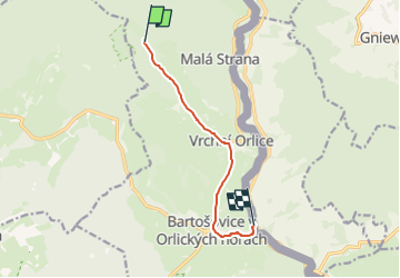

5.4 km | 6.6 km-effort
![Trail On foot Bartošovice v Orlických horách - [Ž] Hadinec - Niemojów - Photo](https://media.geolcdn.com/t/1900/400/e001e748-2d96-4376-b819-e791ec49cc03.jpeg&format=pjpeg&maxdim=2)

Tous les sentiers balisés d’Europe GUIDE+


FREE GPS app for hiking
 SityTrail
IGN / Geographical institutes
SityTrail World
The world is yours!
Trail On foot of 6.3 km to be discovered at Northeast, Královéhradecký kraj, Bartošovice v Orlických horách. This trail is proposed by SityTrail - itinéraires balisés pédestres.
Trail created by cz:KČT.
![Trail On foot Bartošovice v Orlických horách - [Ž] Hadinec - Niemojów - Photo 1](https://media.geolcdn.com/t/2048/auto/59c29bc4-89fc-405b-80b7-5bfd1107836a.jpeg&format=jpg&maxdim=0 "Trail On foot Bartošovice v Orlických horách - [Ž] Hadinec - Niemojów - Photo 1")
![Trail On foot Bartošovice v Orlických horách - [Ž] Hadinec - Niemojów - Photo 2](https://media.geolcdn.com/t/2048/auto/8287d116-4347-4a0f-93d3-6720171654d3.jpeg&format=jpg&maxdim=0 "Trail On foot Bartošovice v Orlických horách - [Ž] Hadinec - Niemojów - Photo 2")
![Trail On foot Bartošovice v Orlických horách - [Ž] Hadinec - Niemojów - Photo 3](https://media.geolcdn.com/t/2048/auto/27256f7d-b1ba-478f-b209-6394b90a3756.jpeg&format=jpg&maxdim=0 "Trail On foot Bartošovice v Orlických horách - [Ž] Hadinec - Niemojów - Photo 3")
![Trail On foot Bartošovice v Orlických horách - [Ž] Hadinec - Niemojów - Photo 4](https://media.geolcdn.com/t/2048/auto/8e95f927-b18a-4560-a4c1-f6f6a0e812f4.jpeg&format=jpg&maxdim=0 "Trail On foot Bartošovice v Orlických horách - [Ž] Hadinec - Niemojów - Photo 4")
![Trail On foot Bartošovice v Orlických horách - [Ž] Hadinec - Niemojów - Photo 5](https://media.geolcdn.com/t/2048/auto/5192a66f-1ec6-44b1-9dca-c6ae2f34e381.jpeg&format=jpg&maxdim=0 "Trail On foot Bartošovice v Orlických horách - [Ž] Hadinec - Niemojów - Photo 5")
![Trail On foot Bartošovice v Orlických horách - [Ž] Hadinec - Niemojów - Photo 6](https://media.geolcdn.com/t/2048/auto/18219852-834f-4435-9628-0baf78b459b2.jpeg&format=jpg&maxdim=0 "Trail On foot Bartošovice v Orlických horách - [Ž] Hadinec - Niemojów - Photo 6")
![Trail On foot Bartošovice v Orlických horách - [Ž] Hadinec - Niemojów - Photo 7](https://media.geolcdn.com/t/2048/auto/2f42831c-d452-4af7-a2f9-1a4f8cf34a8c.jpeg&format=jpg&maxdim=0 "Trail On foot Bartošovice v Orlických horách - [Ž] Hadinec - Niemojów - Photo 7")
![Trail On foot Bartošovice v Orlických horách - [Ž] Hadinec - Niemojów - Photo 8](https://media.geolcdn.com/t/2048/auto/5a2ac0eb-f104-4b97-bac3-6c90b1e67e8f.jpeg&format=jpg&maxdim=0 "Trail On foot Bartošovice v Orlických horách - [Ž] Hadinec - Niemojów - Photo 8")
![Trail On foot Bartošovice v Orlických horách - [Ž] Hadinec - Niemojów - Photo 9](https://media.geolcdn.com/t/2048/auto/e001e748-2d96-4376-b819-e791ec49cc03.jpeg&format=jpg&maxdim=0 "Trail On foot Bartošovice v Orlických horách - [Ž] Hadinec - Niemojów - Photo 9")
![Trail On foot Bartošovice v Orlických horách - [Ž] Hadinec - Niemojów - Photo 10](https://media.geolcdn.com/t/2048/auto/952dfb38-f1ad-4fb0-8b0e-ba03837de95f.jpeg&format=jpg&maxdim=0 "Trail On foot Bartošovice v Orlických horách - [Ž] Hadinec - Niemojów - Photo 10")
![Trail On foot Říčky v Orlických horách - [Ž]-Neratov-Mezivrší - Photo](https://media.geolcdn.com/t/375/260/06627e59-c51a-4814-84ef-9d8c22f20ef1.jpeg&format=jpg&maxdim=2)
On foot
![Trail On foot Rokytnice v Orlických horách - [Z] Říčky v Orl. h. - Horní Rokytnice - Photo](https://media.geolcdn.com/t/375/260/ee733087-daf8-4ced-ba45-cb70cdb3ebdb.jpeg&format=jpg&maxdim=2)
On foot